Objective 01
Water resources
Characterise the water resources available on site and their potential for irrigation and aquaculture.

Land survey · Volume 4 · April 2026
Hydric, topographic and land-cover characterisation and rational parcelling of Block F (5,380 ha) allocated to ZEIDEAL GROUP SAS within the State's "Central Plain" programme.
Full report
This document is Volume 4 of the technical studies under the Memorandum of Understanding signed with MINADER for the Integrated Aqua-Industrial Complex project (PROAQUI). Based on satellite imagery (Sentinel-2, ALOS PALSAR) and field surveys, in the WGS 84 — UTM Zone 33N geodetic reference, it presents the complete characterisation of Block F and its parcelling into 16 sub-blocks and 54 parcels.
Report language: French.
At a glance
Study objectives
The study provides an in-depth analysis of the hydric characterisation and agricultural parcelling of Block F, in the Dir district (Djérem department, Adamaoua region), within the Bagodo agricultural post (villages of Sourma and Raouzanam). It aims to:
Objective 01
Characterise the water resources available on site and their potential for irrigation and aquaculture.
Objective 02
Produce detailed, geo-referenced mapping of the agricultural parcels (WGS 84 — UTM Zone 33N).
Objective 03
Determine elevations, slopes and micro-relief from a digital terrain model (DSM/DTM).
Objective 04
Establish a subdivision accounting for topographic and hydric constraints, for a sound development plan.
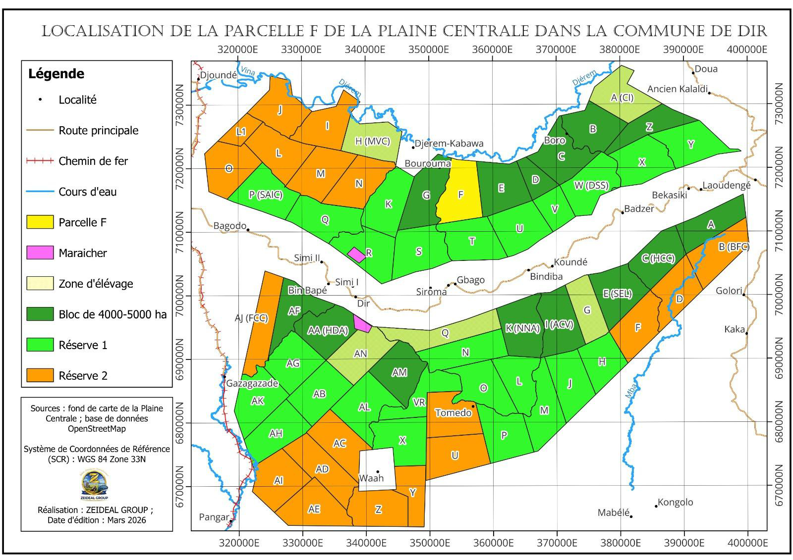
Chapter 1 — Location
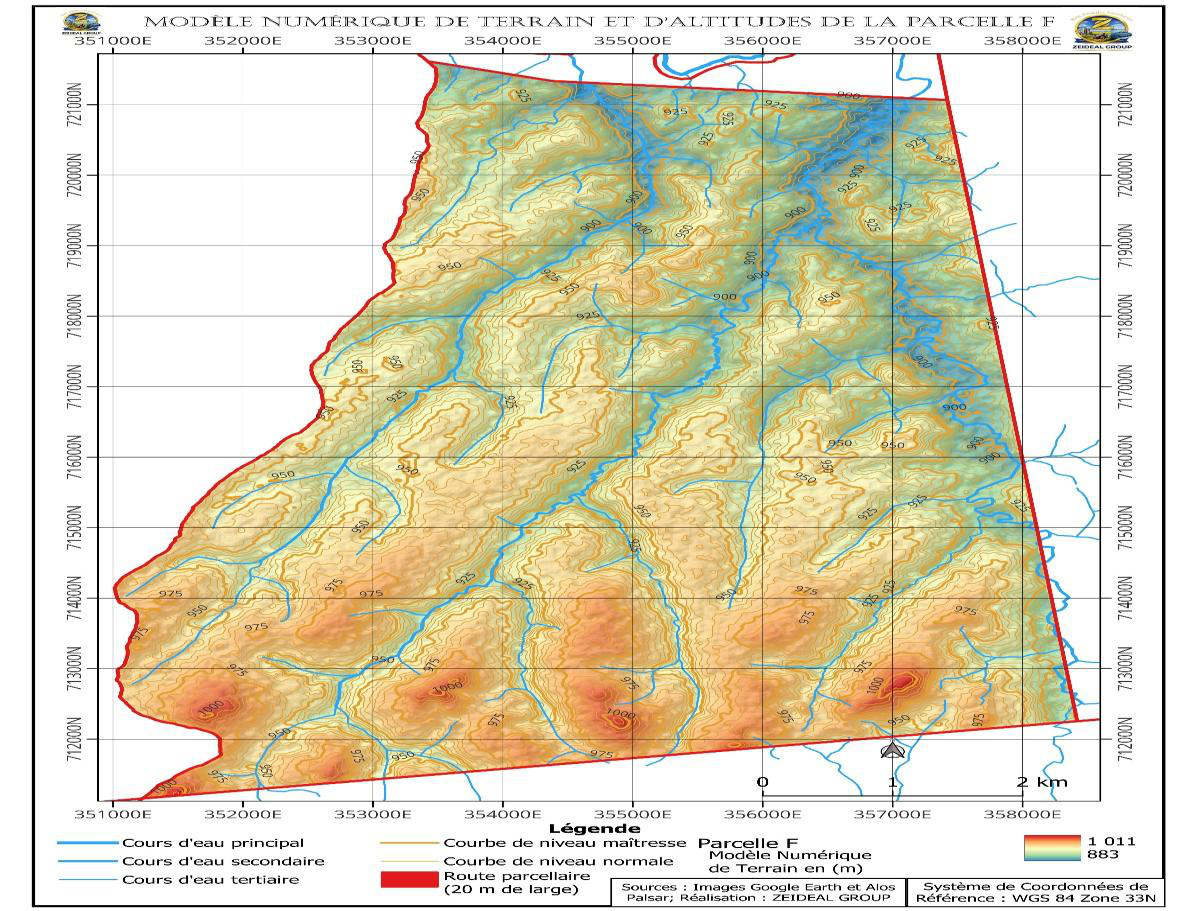
Block F (Parcel F, in yellow) lies within the Central Plain, in the Bagodo agricultural post (Dir commune, Djérem department). It is bounded to the north by the Djérem river and accessed from National Road N°6 near the village of Sourma, on a plateau relief ranging from 883 to 1,011 m in elevation.
Chapter 2 — Characterisation
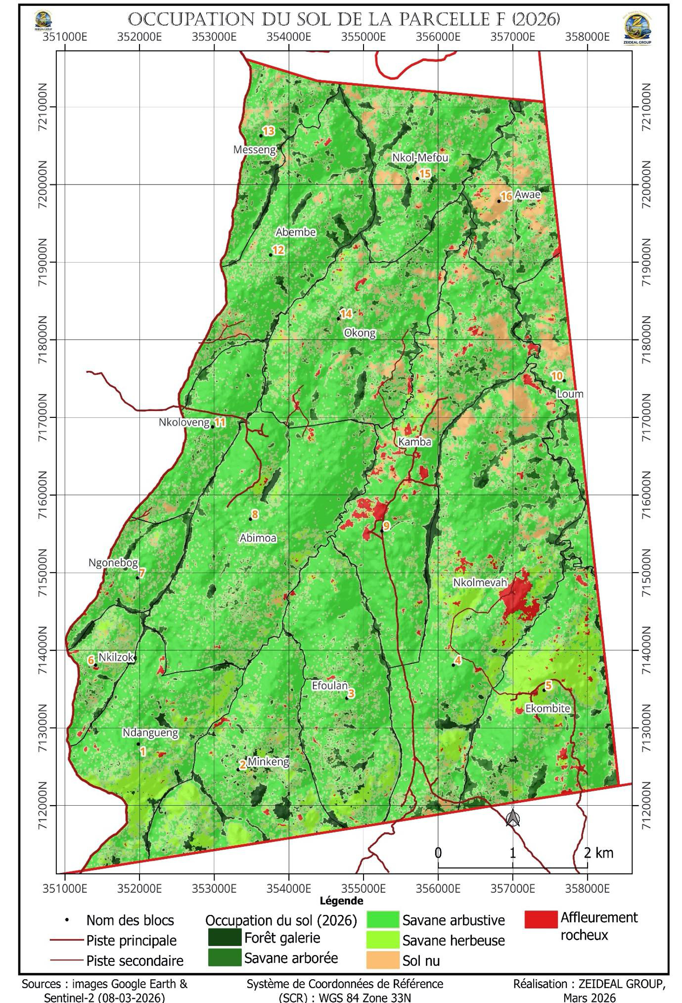
Land-cover mapping relies on Sentinel-2 remote sensing (8 March 2026) and a supervised maximum-likelihood classification (ENVI 4.5 software), with an overall accuracy of 92.85% and a Kappa index of 0.88. Shrub savannah largely dominates, and nearly 93% of the area is suitable for agriculture.
| Land-cover class | Area (ha) | Share (%) |
|---|---|---|
| Shrub savannah | 3,734.09 | 69.42 |
| Tree savannah | 465.68 | 8.66 |
| Grass savannah | 445.74 | 8.29 |
| Bare soil | 357.08 | 6.64 |
| Gallery forest | 228.08 | 4.24 |
| Rocky outcrop | 148.19 | 2.76 |
| Total | 5,378.86 | 100.00 |
Protected areas
Gallery forests, watercourses and rocky outcrops (≈ 7%) are preserved for biodiversity conservation and as natural windbreaks. Rocky outcrops (3%) may host the living base, machinery hubs and maintenance workshops.
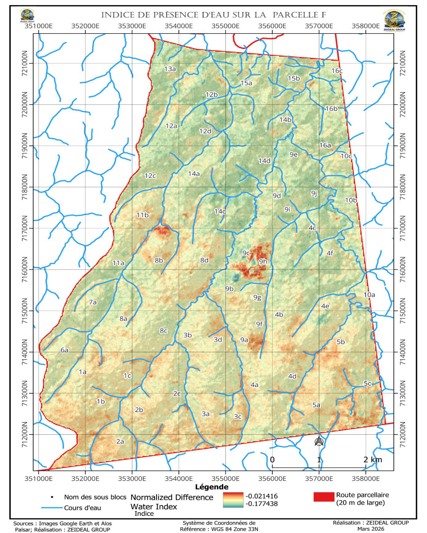
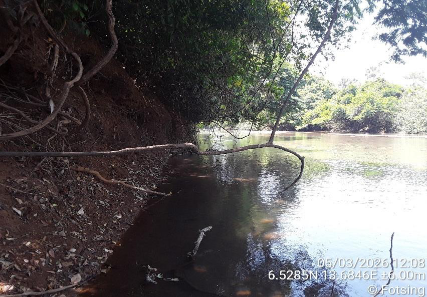
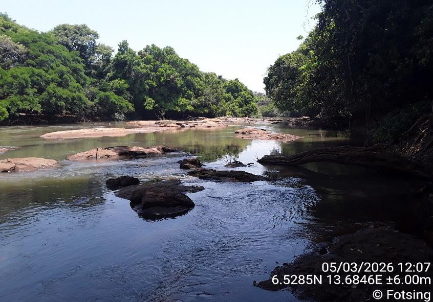
Hydric characterisation
Block F is drained by numerous watercourses, tributaries of the Djérem river to the north, and crossed by three main south-to-north watercourses. The plot lies about 700 m from the Djérem (up to 50 m wide in places) and contains many wetlands. The water-presence index (NDWI) computed in March is negative, reflecting the absence of extensive surface water in the dry season — hence the importance of an irrigation strategy drawing on the Djérem.
| Climate | Tropical Sudano-Guinean, two seasons |
| Rainy season | May to October (peak July–August) |
| Annual rainfall | 1,300 – 1,700 mm |
| Mean temperature | ≈ 24 °C |
| Hydrological regime | Transitional tropical pluvial (specific module < 10 l/s/km²) |
| Geodetic reference | WGS 84 — UTM Zone 33N · ALOS PALSAR |

Chapter 3 — Parcelling
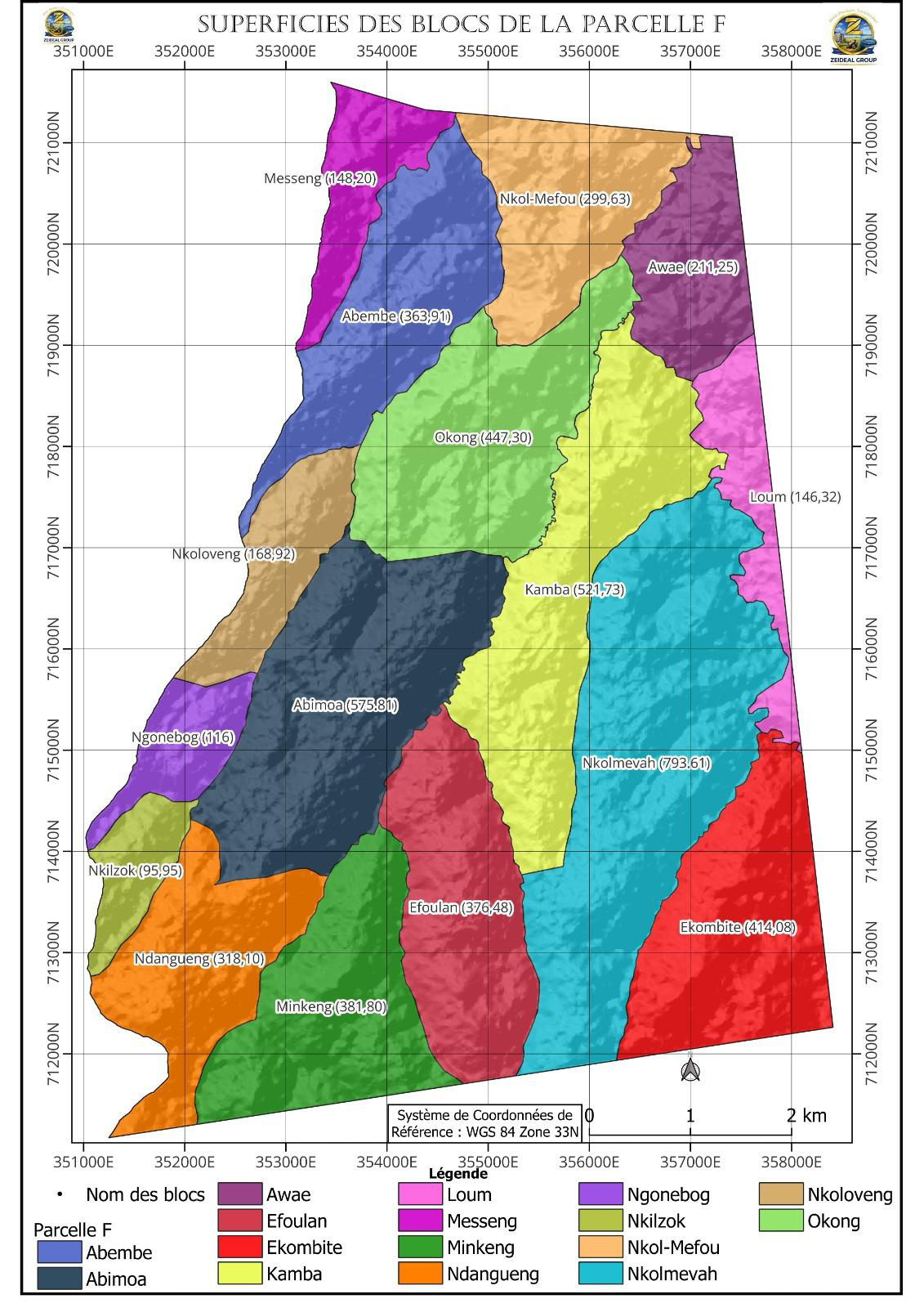
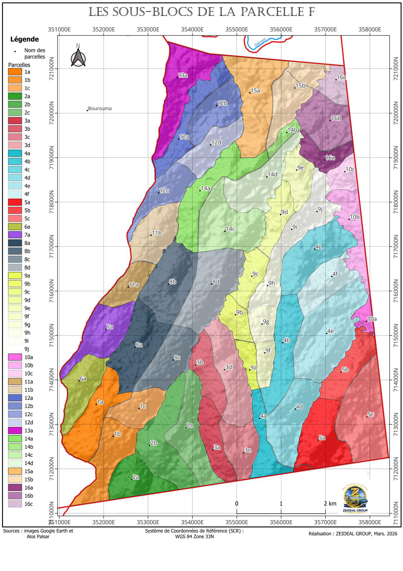
The subdivision accounts for soil type, relief (contour lines), the hydrographic network and existing tracks, in line with the layout proposed by MINADER (at least 100 ha per parcel). Block F is divided into 16 sub-blocks and 54 parcels, totalling 5,406.8 hectares, named after the neighbouring localities.
| Sub-block | Area (ha) | Elevation (m) | Subdivision |
|---|---|---|---|
| Nkolmevah | 793.6 | 891 – 1,002 | 6 parcels |
| Abimoa | 575.8 | 908 – 983 | 4 parcels |
| Kamba | 521.7 | 889 – 966 | 10 parcels |
| Okong | 447.3 | 890 – 966 | 4 parcels |
| Ekombité | 414.1 | 906 – 1,009 | 3 parcels |
| Minkeng | 381.8 | 916 – 1,004 | 3 parcels |
| Efoulan | 376.5 | 913 – 1,006 | 4 parcels |
| Abembé | 363.9 | 885 – 958 | 4 parcels |
| Ndangueng | 318.1 | 925 – 1,011 | 3 parcels |
| Nkol-Mefou | 299.6 | 884 – 957 | 2 parcels |
| Awae | 211.3 | 883 – 947 | 3 parcels |
| Nkoloveng | 168.9 | 906 – 958 | 2 parcels |
| Messeng | 148.2 | 885 – 963 | Single block |
| Loum | 146.3 | 892 – 942 | 3 parcels |
| Ngonebog | 116.0 | 925 – 976 | Single block |
| Nkilzok | 96.0 | 928 – 981 | Single block |
| Total Block F | 5,406.8 | 883 – 1,011 | 54 parcels |
The report's geodetic annex details the boundary coordinates (WGS 84 — UTM Zone 33N) of each of the 16 sub-blocks.
Document contents
Context & rationale · Chapter 1 (Dir basin) · Chapter 2 (characterisation) · Chapter 3 (parcelling) · recommendations & conclusion · geodetic annex.
📄 Download full report (PDF)Navigate the project
The agro-industrial backbone of PROAQUI: 5,380 ha in Adamaoua, irrigated agriculture and a 76,000 t/yr Bühler do Brasil feed mill.
The Integrated Aqua-Industrial Complex: from grain to plate, across CEMAC. Dir, Mbakaou and Nyong sites.